-> GPX <-
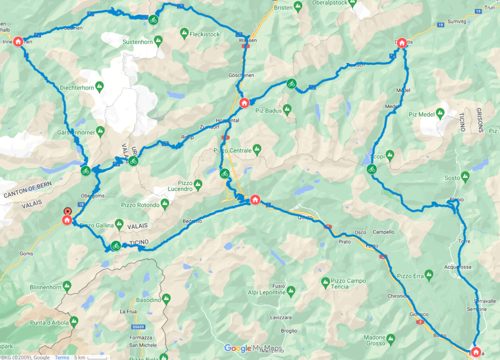
The route is a double loop that starts and ends in the small hamlet of Ulrichen (VS) on the Obergoms plateau. It has a train station, a small supermarket open 7/7 (unusual in Switzerland), restaurant, hotel and a free carpark.
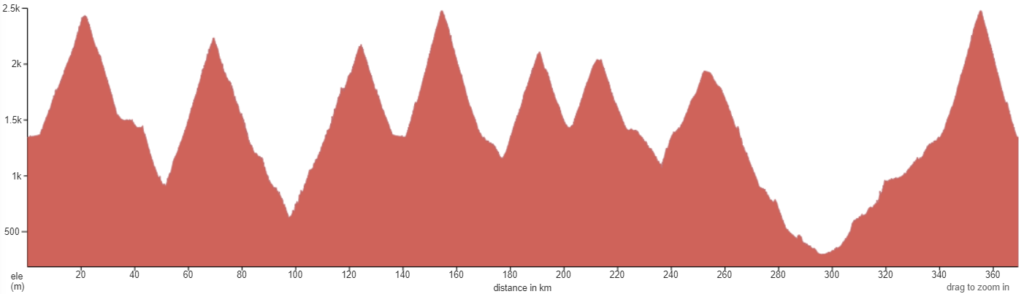
From there, you have a few kilometers on a nice flat cycle way along the river for a quick warm up before the climbing feast starts with a grand opening : Furka.
Beware that the first loop is often higly frequentend with tourist cars and motos during high season, especially on week-ends. The roads are wide and perfectly maintained but some unwise time planning could darken your experience here. Nonetheless, there is a lot of cyclists too and Swiss drivers are usually very respectful of other road users.
The winding road makes steadily its way up the forest before reaching the alpine environnement and 360° jaw droping views on the surronding moutains and the Furka Glacier all the way to the pass and further down the Uri side, towards Andermatt and Wassen.
Fill up your bottles at the fountain right at the crossing before you embark on the second climb of the day (or night) towards the Susten, one of the most demanding climb of the Challenge. Once a the top, you’re in for a very long descent through typical swiss landscapes of green pastures sprinkled with wooden chalets.
Once in Innertkirchen, make sure you’re fueled up for the biggest and longest pass, the Grimsel. The lenght of the climb flattens the elevation gain but you’re still getting 1500m of ascent in one go. This is where you may encounter the most traffic but you will understand why once you reach the top. Enjoy the cool breeze and all the small buvettes as you’ll need all your abilities for the fast descent back to Ulrichen.
Here starts the steepest climb on a fairly remote road to the Nufenen, highest point of the route and second highest road pass in Switzerland. You will notice the climate difference once you start descending in Ticino. Watch out, this is the only section of lower quality asphalt and fatigue probably starts to creep in.
Summer can be very dry in the Airolo area and fountains could be shut down so make sure you have everything you need before embarking on the Tremola and it’s famous pavés leading to the Gotthard, one of the most iconic climb in Europe. The bypass tunnel absorbs most of the traffic so you shouldn’t encounter too many people here. The first part of the descent is still on pavés before the Tremola merges back onto the main road connecting Uri and Ticino and its five star tarmac.
Andermatt is a small Alpine Town and arguably the biggest settlement of the route with a wide choice of food and services making it a nice pit stop before the shortest climb of the challenge to Oberalp. At the top, you cross the border with the fifth and last canton, enterring Graubunden. The road gently descent to Disentis where its bifurcates towards the less-known and off-the-beaten track Lucomagno.
You’re in for the longest descent to the lowest point of the itinerary, Biasca sitting at 300m above sea level. You only have one ascent left! Well that was the good news. The sad one is that from here you still have to climb all the bay back up to Nufenen. Yes, that’s lowest to highest point, over 60,9km. Some will say that the climb actually only starts in Airolo but one or two steep sections will help you understand you are making your way up already. The last section with its long 10% avg straight lines may get you swearing and suffering but you’re almost there, congrats !
Once atop you can just let yourself fall in the arms of gravity which will rapidly lead you back to Ulrichen, unforgettable memories and some well deserved rest.